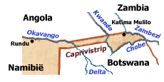
 Caprivi Strip
The Caprivi Strip is a part of Namibia and it’s a protrusion located to the east of Okavango Region, with Zambia and Angola in the north and Botswana in the south. This region has the rivers Zambezi, Chobe, Kwando and Okavango as borders. The biggest settlement on the Caprivi Strip is called Katima Mulilo, a town with a population of 28,000. The regions that have control over Caprivi Strip are Okavango Region and Caprivi Region. The place is quite typical, with its round huts placed in the vicinity of the street, and its climate, wet and tropical. The length of this protrusion of land is around 450km.
 It’s a region that has plenty of mineral resources, but also a diverse and rich wildlife. The reason why the Namibian government thinks it’s important is mostly because it gives them access to Zambezi, a river which can be used as a trading route within East Africa. That’s not likely to happen for a number of reasons, including the presence of rapids, the fact that the level of the river is not constant and because Victoria Falls is present downstream as well. The political situation in the region doesn’t help either, so the most likely result is that the Caprivi Strip will become an ecotourism destination.
There are a total of three national parks present within Caprivi and the Wild African Dog, which is endangered, has found an important habitat in the area.
The name Caprivi comes from Leo von Caprivi, a German Chancellor which negotiated with the British for the purchase of this land, at the end of the 19th century. The purpose behind the acquisition was to give the German colonies from Africa a trade route with the rest of Africa, through the Zambezi river. Since the river couldn’t be navigated, the plan was abandoned.